


Welcome to the South Carolina Insurance Agency - Your SC Insurance Experts, Featuring Top Agencies, Agents, and Companies
Insurance Shopping Experts
We are an independent insurance agency that specializes in shopping around for the best rate for all your insurance needs. We know that finding a low rate on insurance can be a hassle. We help our clients by matching their risk to the insurance company that will give them the best rate. We have multiple insurance companies that will compete for your insurance business. Our job is to match you with the best rate for your situation and provide a path for future cost savings on all your insurance needs. No need to come to us our agents are mobile and can help you wherever they are! We can meet through zoom or phone and can get most service things done through email or our contact form.
 We make buying insurance easy!

Car Insurance
Find The Best Rates For Your Car Insurance Needs In South Carolina What Do I Need To Get A Car Insurance Quote In South Carolina? It …
Car Insurance
Homeowners Insurance
Home insurance in South Carolina protects you from total financial loss against disasters.
Homeowners Insurance
Boat Insurance In South Carolina
Find The Best Rates For Your Boat And Jet Ski Insurance Needs In South Carolina Having boat insurance in South Carolina allows you to enjoy …
Boat Insurance
Renters Insurance In South Carolina
Find The Best Rates For Your Renters Insurance Needs In South Carolina What Do I Need To Get A Renters Insurance Quote In South Carolina? Name …
Renters Insurance
Classic Car Insurance Discounts In South Carolina
Classic Car Insurance Discounts In South Carolina Classic car insurance has some great discounts available to help lower the price of your classic …
Classic Car Insurance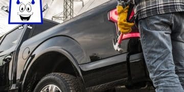
Commercial Auto Insurance
Find The Best Rates For Your Commercial Auto Insurance Needs In South Carolina Commercial auto insurance. Commercial auto insurance in South …
Commercial Auto Insurance
Motorcycle Insurance In South Carolina
Find The Best Rates For Your Motorcycle Insurance Needs In South Carolina What Is Motorcycle Insurance? Motorcycle insurance is a type …
Motorcycle Insurance
Condo Insurance In South Carolina
Find The Best Rates For Your Condo Insurance Needs In South Carolina What Do I Need To Get A Condo Insurance Quote In South Carolina? Year …
Condo Insurance
Landlord Rental Property Insurance In South Carolina
Find The Best Rates For Your Landlord Rental Property Insurance Needs In South Carolina What Do I Need To Get A Landlord Rental Property …
Landlord Insurance
RV Recreational Vehicle Insurance In South Carolina
Find The Best Rates For Your RV Recreational Vehicle Insurance Needs In South Carolina What Is RVInsurance? RV insurance is a type …
RV Insurance
Valuable Items Insurance In South Carolina
Find The Lowest Rates For Your Valuable Items Insurance Needs In South Carolina What Do I Need To Get A Valuable Items Insurance Quote In …
Valuable Items Insurance
Navigating Renters Insurance in Columbia, SC: Your Comprehensive Protection Guide


Renters Insurance In Columbia, SC, What You Need To Know
Why Home Insurance Premiums Are Rising in South Carolina